
Ohio Map
 |
 |
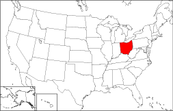
Where Is Ohio?
The State of Ohio, highlighted on this map, is bordered by Lake Erie on the north, by Pennsylvania on the east, and by Indiana on the west. Ohio is bounded by West Virginia on the southeast, by Michigan on the northwest, and by Kentucky on the southwest.
Ohio Maps
Ohio is the 35th largest state in the United States, and its land area is 40,948 square miles (106,055 square kilometers). The state is divided into 88 counties. This Ohio map site features road maps, topographical maps, and relief maps of Ohio. The detailed, scrollable road map displays Ohio counties, cities, and towns as well as Interstate, U.S., and Ohio state highways. The pannable, scalable Ohio street map can be zoomed in to show local streets and detailed imagery.
Ohio Highway Map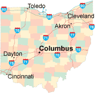 Click on the highway map thumbnail
to view a scalable Ohio road map. |
OH Topo Map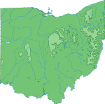 Click map to enlarge.
|
OH Relief Map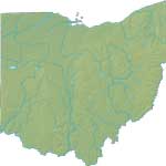 Click map to enlarge.
|
The detailed Ohio map and the regional Ohio map display cities, roads, rivers, and lakes as well as terrain features. The detailed map shows only the State of Ohio, while the regional map shows Ohio and the surrounding region.
Ohio Infrastructure > Ohio Airports
In 2005, the population of Ohio was estimated at 11,470,685, which is about 280.0 people per square mile. In 2010, Ohio's population rose to 11,536,504 people. More recently, in the 2020 census, the Ohio population was 11,799,448. The state's Interstate Highways include I-70, I-71, and I-75 as well as I-77, I-80, and I-90.
Ohio Topography
Ohio is derived from an Iroquois word meaning "great river". From its wooded hill country in the south, Ohio's terrain descends gradually toward the shores of Lake Erie in the north. The Buckeye State is drained by the Ohio, Scioto, and Miami Rivers, among others. Tourist attractions include Cedar Point resort, homes of several presidents, and numerous museums. Visit the official Ohio tourism site and Ohio Atlas for Ohio travel and tourism information.
Other Maps of Ohio
This Ohio reference map shows major cities, roads, railroads, and physical features in Ohio.Several map publishing companies offer printed maps of Ohio. For example, Omni Resources offers several maps of Ohio that feature points of interest, airports, and parks, as well as selected local attractions and insets of major Ohio cities.
All rights reserved.
Certain maps hereon are © Map Resources or Digital Wisdom.
To facilitate browsing, certain external links will open in new windows.
Ohio-Map.org Editor, State Maps, PO Box 828, Barnegat, NJ 08005.